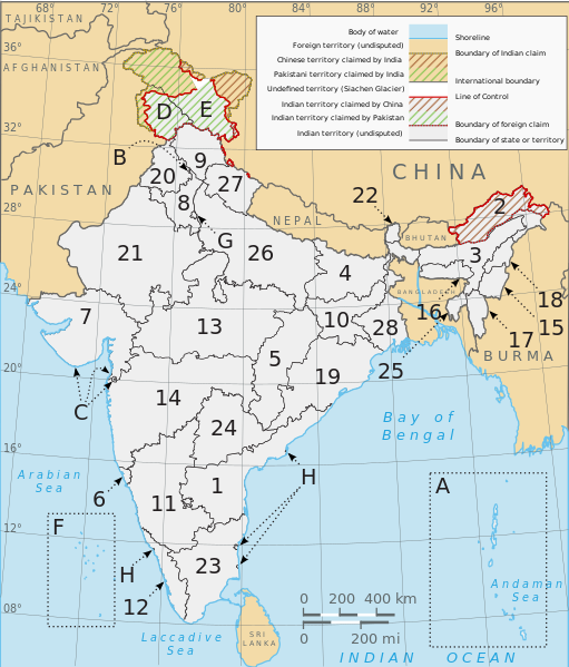
Abruozdielis:Political map of India EN.svg

Rinkmenos SVG peržiūros PNG dydisː 511 × 599 pikselē. Kėtū dėdlomu: 205 × 240 pikselē | 410 × 480 pikselē | 655 × 768 pikselē | 874 × 1 024 pikselē | 1 748 × 2 048 pikselē | 1 594 × 1 868 pikselē.
Pradėnis abruozdielis (SVG skvarmou, fuormalē 1 594 × 1 868 puškiu, skvarmenė dėdloms: 325 KiB)
Abruozdielė istuorėjė
Paspauskėt ont deinas/čiesa, ka paveizietomėt abruozdieli, kāp ons ėšruodė pradiuo.
| Dėina/Čiesos | Pamažėnėms | Mierā | Nauduotuos | Paāškėnėms | |
|---|---|---|---|---|---|
| vielībs | 16:49, 28 siejės 2022 |  | 1 594 × 1 868 (325 KiB) | ऐक्टिवेटेड् | File uploaded using svgtranslate tool (https://svgtranslate.toolforge.org/). Added translation for sa. |
| 22:30, 27 rogpjūtė 2022 |  | 1 594 × 1 868 (312 KiB) | Johano | File uploaded using svgtranslate tool (https://svgtranslate.toolforge.org/). Added translation for eo. | |
| 01:34, 24 rogpjūtė 2022 |  | 1 594 × 1 868 (310 KiB) | Johano | File uploaded using svgtranslate tool (https://svgtranslate.toolforge.org/). Added translation for eo. | |
| 08:30, 3 lėipas 2020 |  | 1 594 × 1 868 (300 KiB) | Jfblanc | removed I-mark and replaced by H (thanks Wassermaus!) | |
| 18:56, 7 balondė 2020 |  | 1 594 × 1 868 (299 KiB) | Jfblanc | Merger of UTs of Dadra & Nagar Haveli with Daman and Diu (26 January 2020). | |
| 10:47, 19 lapkristė 2019 |  | 1 594 × 1 868 (293 KiB) | Getsnoopy | Complete code overhaul for easier manipulation. Corrected JK and Ladakh border in PaK. Adjusted some label positions and some other styles. | |
| 23:12, 8 lapkristė 2019 |  | 1 594 × 1 868 (318 KiB) | Getsnoopy | Reverted to version as of 14:11, 2 November 2019 (UTC) | |
| 23:10, 8 lapkristė 2019 |  | 1 594 × 1 868 (291 KiB) | Getsnoopy | Complete code overhaul for easier manipulation. Corrected JK and Ladakh border in PaK. Adjusted some label positions and some other styles. | |
| 17:11, 2 lapkristė 2019 |  | 1 594 × 1 868 (318 KiB) | RaviC | adjustments made following publication of official boundaries of new UTs | |
| 05:06, 1 lapkristė 2019 |  | 1 594 × 1 868 (318 KiB) | Getsnoopy | Fixed Puducherry's letter mappings, and made some minor arrow adjustments as a result. |
Abruozdieliu nauduojėms
Ons poslapis ruod ton abruozdielin:
Abruozdielė nauduojėms vėsor
Tėi viki poslapē nauduo šėton abruozdieli:
- Skvarmas nauduojėms ace.wikipedia.org
- Skvarmas nauduojėms as.wikipedia.org
- Skvarmas nauduojėms be-tarask.wikipedia.org
- Skvarmas nauduojėms bh.wikipedia.org
- Skvarmas nauduojėms bn.wikipedia.org
- Skvarmas nauduojėms bs.wikipedia.org
- Skvarmas nauduojėms cs.wikipedia.org
- Skvarmas nauduojėms da.wikipedia.org
- Skvarmas nauduojėms en.wikipedia.org
- India
- ISO 3166-2:IN
- Central Reserve Police Force
- List of Indian state and union territory name etymologies
- Outline of India
- Talk:States of India
- Template:Indian states and territories image map
- User:RajatTikmany
- User:Srujan1001/sandbox
- User:RexxS/India (no clear)
- User:RexxS/India (20em cols)
- User:RexxS/India (15em cols)
- User:Berek/India
- Talk:India/Archive 46
- Skvarmas nauduojėms eo.wikipedia.org
- Skvarmas nauduojėms es.wikipedia.org
- Skvarmas nauduojėms fi.wikipedia.org
- Skvarmas nauduojėms fr.wikipedia.org
- Skvarmas nauduojėms gl.wikipedia.org
- Skvarmas nauduojėms he.wikipedia.org
Veizietė, kāp vėsor tasā abruozdielis nauduojams īr.

