Abruozdielis:Map of Sendai Earthquake 2011.jpg

Pradėnis abruozdielis ((897 × 749 taškū, faila dėdoms: 606 KiB, MIME tips: image/jpeg))
| Tas abruozdielis īr ėš Vikitėkuos arkīvu. Anuo orėgėnalos aprašėma poslapis īr čiuonās. |
Paāškėnėms
| Aprašīms |
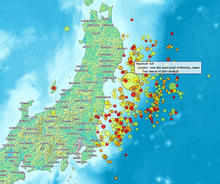
English: Map of the Sendai Earthquake 2011 and aftershocks until March 14, 2011 at 11:20. The size of the circles is a function of magnitude, and the color indicates the date: light green: March 11; yellow: March 12; orange: March 13; red: March 14.
Français : Carte des épicentres et de l'intensité des secousses du tremblement de terre de Sendai du 14 mars 2011. La taille des cercles est fonction de la magnitude, leur couleur indique la date : vert clair, 11.3.2011 ; jaune, 12.3.2011 ; orange, 13.3.2011 ; rouge 14.3.2011.
日本語: 2011年3月11日に発生した東北地方太平洋沖地震、および同14日11時20分までの余震を示した地図。円はマグニチュード、色は発生した日付(黄緑:3月11日、黄:3月12日、橙:3月13日、赤:3月14日)を示す。 |
| Čiesos | |
| Šaltėnis | http://www2.demis.nl/quakes/ |
| Kūries | www2.demis.nl, Uploader User:Heinz-Josef Lücking |
| Laidėms (Abruozdielė parnauduojėms) |
Public domain according to http://www2.demis.nl |
|
Šis failas yra viešo naudojimo tose šalyse, kuriose autorių teisės galiojimo netenka po 70 metų nuo autoriaus mirties.
| |
| This file has been identified as being free of known restrictions under copyright law, including all related and neighboring rights. | |
Lėcencėjė
This image is in the public domain because it came from the site https://www.demis.nl/products/web-map-server/examples/ and was released by the copyright holder. Permission is granted to copy, distribute and/or modify this map since it is based on free of copyright images from: www.demis.nl. See also approval email on de.wp and its clarification.
|
| This work has been released into the public domain by its copyright holder, www.demis.nl. This applies worldwide. Kai kuriose šalyse tai negali būti legaliai leidžiama; jei taip: www.demis.nl suteikia teisę naudoti šį darbą bet kokiai paskirčiai, be jokių sąlygų, nebent jos reikalaujamos įstatymų.
|
| Šis failas prieinamas pagal Creative Commons CC0 1.0 Universal Public Domain Dedication. | |
| Asmuo, kuris susiejo darbą su šiuo dokumentu, nusprendė darbą pateikti Commons, atsisakydamas visų savo autoriaus teisių į darbą visame pasaulyje bei visų susijusių ar gretutinių teisių, kurias jis ar ji turėjo, tiek, kiek leidžia įstatymas. Darbai pagal CC0 atsisakymą nereikalauja autoriaus paminėjimo. Kai darbas cituojamas (naudojamas kitur), neprivalote gauti autoriaus patvirtinimo.
|
Abruozdielė istuorėjė
Paspauskėt ont deinas/čiesa, ka paveizietomėt abruozdieli, kāp ons ėšruodė pradiuo.
| Dėina/Čiesos | Pamažėnėms | Mierā | Nauduotuos | Paāškėnėms | |
|---|---|---|---|---|---|
| vielībs | 00:31, 15 kuova 2011 | | 897 × 749 (606 KiB) | Heinz-Josef Lücking | 14.3 + legend description |
| 07:27, 13 kuova 2011 |  | 1 362 × 1 386 (1,41 MiB) | Stanqo | 4h05m UTC, 13.03.2011 | |
| 14:10, 12 kuova 2011 |  | 1 197 × 1 245 (885 KiB) | Yuma | higher resol. | |
| 13:27, 12 kuova 2011 |  | 928 × 694 (470 KiB) | Yuma | update | |
| 20:20, 11 kuova 2011 |  | 1 006 × 773 (596 KiB) | Heinz-Josef Lücking | actual 2011-03-11 18:20 | |
| 14:19, 11 kuova 2011 |  | 1 014 × 779 (598 KiB) | Erdbeben20110311 | actuality | |
| 12:39, 11 kuova 2011 |  | 1 009 × 683 (522 KiB) | Erdbeben20110311 | {{Information |Description ={{en|1=Map of the Senadai Earthquake 2011}} |Source =http://www2.demis.nl/quakes/ |Author =www2.demis.nl |Date =2011-03-11 |Permission = |other_versions = }} Public domain according to http://ww |
Abruozdieliu nauduojėms
Ons poslapis ruod ton abruozdielin:
Abruozdielė nauduojėms vėsor
Tėi viki poslapē nauduo šėton abruozdieli:
- Skvarmas nauduojėms af.wikipedia.org
- Skvarmas nauduojėms als.wikipedia.org
- Skvarmas nauduojėms ar.wikipedia.org
- Skvarmas nauduojėms ast.wikipedia.org
- Skvarmas nauduojėms az.wikipedia.org
- Skvarmas nauduojėms bcl.wikipedia.org
- Skvarmas nauduojėms be-tarask.wikipedia.org
- Skvarmas nauduojėms be.wikipedia.org
- Skvarmas nauduojėms ca.wikipedia.org
- Skvarmas nauduojėms cu.wikipedia.org
- Skvarmas nauduojėms da.wikipedia.org
- Skvarmas nauduojėms de.wikipedia.org
- Skvarmas nauduojėms el.wikipedia.org
- Skvarmas nauduojėms en.wikipedia.org
- Skvarmas nauduojėms en.wikibooks.org
- Skvarmas nauduojėms eo.wikipedia.org
- Skvarmas nauduojėms es.wikipedia.org
- Skvarmas nauduojėms es.wikinews.org
- Skvarmas nauduojėms eu.wikipedia.org
- Skvarmas nauduojėms fi.wikipedia.org
- Skvarmas nauduojėms fr.wikipedia.org
- Skvarmas nauduojėms ga.wikipedia.org
- Skvarmas nauduojėms he.wikipedia.org
- Skvarmas nauduojėms hr.wikipedia.org
- Skvarmas nauduojėms hu.wikipedia.org
- Skvarmas nauduojėms id.wikipedia.org
- Skvarmas nauduojėms is.wikipedia.org
- Skvarmas nauduojėms it.wikinews.org
- Skvarmas nauduojėms ja.wikipedia.org
- Skvarmas nauduojėms ko.wikipedia.org
- Skvarmas nauduojėms ksh.wikipedia.org
- Skvarmas nauduojėms lt.wikipedia.org
- Skvarmas nauduojėms mrj.wikipedia.org
- Skvarmas nauduojėms ms.wikipedia.org
- Skvarmas nauduojėms nl.wikipedia.org
- Skvarmas nauduojėms nn.wikipedia.org
- Skvarmas nauduojėms no.wikipedia.org
Veizietė, kāp vėsor tasā abruozdielis nauduojams īr.